
Built for people who actually work with the regulation: voyage operators, charterers, shipowners, bunker buyers, calculator and analytics tool builders. The open web has no single source where current boundaries, coordinates, effective dates, and clear maps for all zones live in one consistent frame. We assembled it here.
Coordinate sources are official IMO documents (MEPC resolutions, MEPC.1 circulars, and the coordinate tables on imo.org). Polygons are published here as
polygons.geojson(for GIS tooling) and live in the rynda voyage-economics calculator (for reproducible voyage estimates).
📖 Also available: Interactive map · GeoJSON data
Contents
- At a glance
- Full zone registry
- Historical timeline
- What "being in an ECA" means
- Per-zone deep dives
- Lookalike rules — China, Hong Kong, California
- Bunker fuel in practice
- For developers
- FAQ
- References
At a glance
The short version, if you read nothing else:
- 9 polygons covering 7 ECA zones as of 2026.
- Each zone enforces one or both of MARPOL Annex VI's two regulatory tools:
- Reg 14 — fuel sulphur content ≤ 0.10 % m/m (vs. the 0.50 % global cap)
- Reg 13 — NOx Tier III standard for newbuilds (~80 % reduction vs. Tier I)
- 5 zones in force today (Baltic, North Sea, North American, US Caribbean, Mediterranean SOx since 1 May 2025).
- 2 zones bite for SOx on 1 March 2027 (Canadian Arctic, Norwegian Sea).
- Hawaiian Islands is a separate polygon that belongs to the North American ECA — frequently forgotten because the archipelago is 2,500 nm from the mainland.
- Mediterranean SECA is SOx + PM only, no NOx requirement.
Global overview
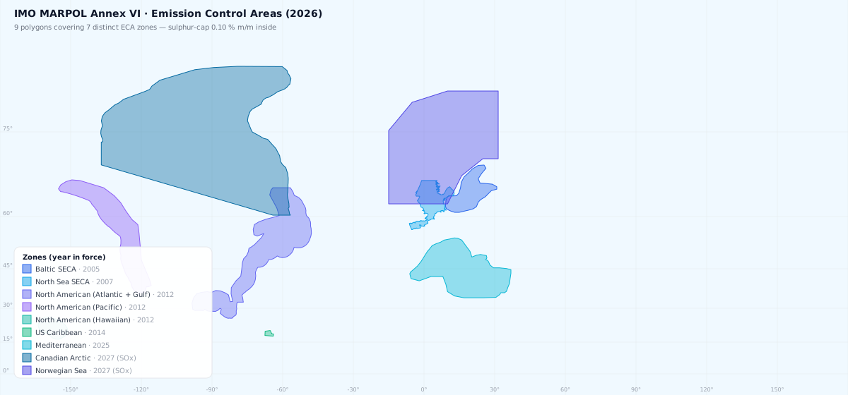
Every map here is clickable — it opens the interactive map, zoomed to that zone.
Full registry
| # | Zone | Reg | SOx ≤ 0.10 % | NOx Tier III | Polygon source | Points |
|---|---|---|---|---|---|---|
| 1 | Baltic SECA | 14 | from 19.05.2005 | — | calibrated to IMO description | 38 |
| 2 | North Sea + English Channel SECA | 14 | from 22.11.2007 | — | calibrated to IMO description | 726 |
| 3 | North American — Atlantic + Gulf of Mexico | 13 + 14 | from 01.08.2012 | newbuilds since 01.01.2016 | IMO Reg 13.6.1 (206 pts) + landward coastal closure | 247 |
| 4 | North American — Pacific | 13 + 14 | from 01.08.2012 | newbuilds since 01.01.2016 | IMO-binding (MEPC.190(60), 47 official vertices) | 74 |
| 5 | North American — Hawaiian Islands | 13 + 14 | from 01.08.2012 | newbuilds since 01.01.2016 | IMO-binding (MEPC.1/Circ.723, 45 pts) | 45 |
| 6 | US Caribbean ECA | 13 + 14 | from 01.01.2014 | newbuilds since 01.01.2016 | IMO-binding (Reg 13.6.2, 55 pts) | 55 |
| 7 | Mediterranean SECA | 14 | from 01.05.2025 | — | calibrated to MEPC.361(79) | 52 |
| 8 | Canadian Arctic ECA | 13 + 14 | from 01.03.2027 | newbuilds since 01.03.2026 | IMO-binding (MEPC.392(82), 179 pts) | 180 |
| 9 | Norwegian Sea ECA | 13 + 14 | from 01.03.2027 | newbuilds since 01.03.2026 | EEZ envelope (MARPOL Annex II Reg 13.9.4) | 12 |
"Reg 14" = MARPOL Annex VI Regulation 14 — SOx + particulate matter control. "Reg 13" = NOx control, applies only to new engines installed after the relevant date.
Historical timeline
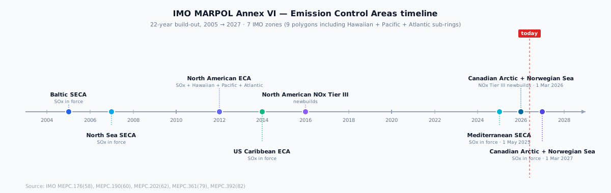
The cadence has accelerated. From 2005 to 2014 four zones came online over nine years, mostly Atlantic-facing. Then a 10-year quiet period, broken in 2025 by the Mediterranean SECA — the first SOx ECA in a non-OECD-anchored sea. 2026/2027 brings two more (Canadian Arctic and Norwegian Sea) on the back of one MEPC resolution. Sulphur regulation has become the default frame for any new IMO ECA discussion; the Indian Ocean and West Africa are next-likely candidates per industry watchers.
What "being in an ECA" actually means
Fuel (Reg 14)
Inside an ECA-SOx zone a ship must burn fuel with sulphur content ≤ 0.10 % m/m. In practice this is one of four options:
| Fuel | Sulphur | Where to bunker |
|---|---|---|
| MGO / LSMGO (Marine Gas Oil 0.10 %) | ≤ 0.10 % | mainstream choice, available everywhere |
| ULSFO (Ultra-Low Sulphur Fuel Oil) | ≤ 0.10 % | scarcer, in major hubs |
| LNG | 0 % | requires LNG-capable or dual-fuel engine |
| HSFO + scrubber | 3.50 % FO, 0.10 % equivalent at outlet | scrubber = EGCS (exhaust gas cleaning system); permitted as equivalent under Reg 14.4 |
Scrubbers (EGCS) are the common strategy on larger vessels: burn cheap HSFO, clean the SOx exhaust. Legal as an equivalent under Reg 14.4 provided outlet emissions meet the 0.10 % equivalent.
Scrubbers split into open-loop (overboard wash water) and closed-loop (recirculating). Many ports restrict open-loop operation: Singapore, Fujairah, China (selectively), several EU ports. That's a separate regulatory layer beyond IMO.
NOx (Reg 13)
The Tier III standard requires ~80 % NOx reduction vs. Tier I. Applies only to engines installed on:
- Ships with a building contract placed after the relevant date (or keel laid 6 months after, or delivered 4 years after).
- Engines on existing ships continue to run Tier I / II — no retrofit required.
In the rynda voyage-economics calculator NOx Tier III doesn't affect bunker grade allocation, so we don't model it separately. But for newbuild capex modelling it matters — Tier III requires SCR or EGR, adding to vessel build cost.
What ECA does NOT require
- No prohibition on entry. You can enter the zone and switch fuel mode on any day.
- No requirement to bunker-change at the moment of crossing. But you must be on compliant fuel before entering the zone. Standard practice: changeover 1-2 hours before planned crossing.
- Doesn't cancel the global 0.50 % cap — that stays in parallel. There are also separate local rules (Chinese DECAs, Hong Kong at-berth, California 24 nm etc.) that can be even stricter.
Per-zone deep dives
1. Baltic SECA
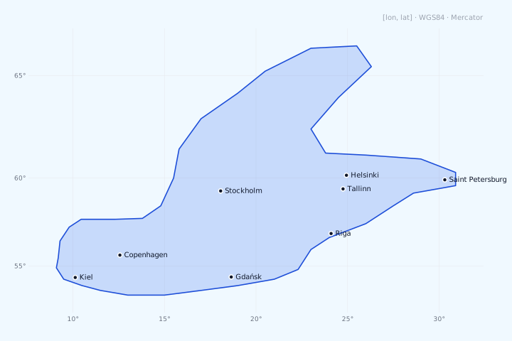
Source: MARPOL Annex VI Reg 14.3(a)(i) · MEPC.176(58) · in force since 19.05.2005.
Coverage: Entire Baltic Sea — Baltic proper, Gulf of Bothnia (to ~66°N at the Tornio/Kemi cap), Gulf of Finland, Gulf of Riga, Stockholm archipelago — plus the Kattegat up to the Skagen parallel (57°44.8′N), which MARPOL Annex VI assigns to the Baltic SECA.
Excludes: The Skagerrak (that's North Sea SECA territory — handover at the Skagen parallel) and everything west of it. The Kattegat, once listed here as excluded, is in fact inside the Baltic SECA under MARPOL Annex VI — corrected in the 2026 boundary revision.
Major ports inside: Saint Petersburg, Riga, Klaipėda, Gdańsk, Copenhagen, Stockholm, Helsinki, Tallinn, Kiel.
Notes:
- The oldest SECA zone in the world.
- Polygon covers the entire Baltic Sea up to ~66°N (Tornio/Kemi cap at the head of the Bothnian Bay).
- Gulf of Finland extends to 30.5°E (Saint Petersburg is inside).
Full 38-coordinate list · GeoJSON fragment
2. North Sea + English Channel SECA
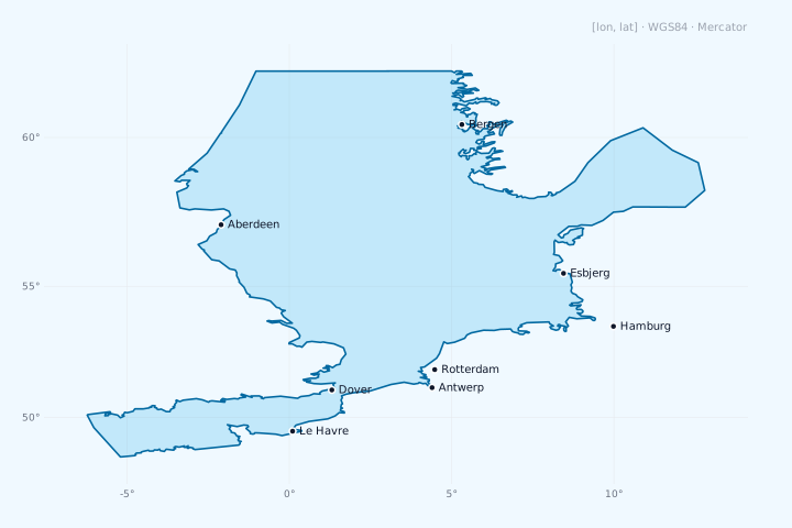
Source: MARPOL Annex VI Reg 14.3(a)(ii) · MEPC.190(60) · in force since 22.11.2007.
Coverage: North Sea from 62°N (south of the Faroe Islands and Shetland), west to 5°W (Channel Approaches), including the English Channel and the coasts of Norway (to Bergen — northern Norway is separately covered by the Norwegian Sea ECA), Denmark, Germany, the Netherlands, Belgium, France.
Excludes: Celtic Sea west of 5°W (Brest approaches OK, further west not). Atlantic side of Scotland west of 9°W — IMO gives 5°W but the polygon practically extends a touch further west around the Hebrides. Skagerrak up to Skagen — yes, inside; further south in Kattegat — handover to Baltic SECA.
Major ports inside: Rotterdam (world's #1 bunker port), Antwerp, Hamburg, Bremen, Le Havre, Felixstowe, Aberdeen, Bergen.
Notes:
- Border with Baltic SECA runs through Skagerrak — handover at Skagen.
- South-west anchor: Ushant (-5°W, 48.5°N).
- North cap: 62°N through Shetland — beyond that is open until Norwegian Sea SECA bites in 2027.
- Entire English Channel inside — every grade (LSMGO/VLSFO/ULSFO) from Dover to Brest.
3. North American ECA — Atlantic + Gulf of Mexico
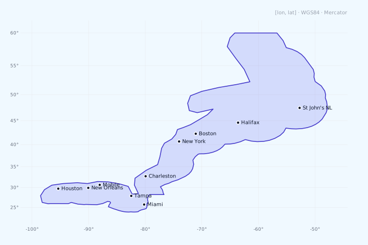
Source: MARPOL Annex VI Reg 13.6.1 + 14.3.3 · MEPC.190(60) + MEPC.202(62) · SOx from 01.08.2012 · NOx Tier III for newbuilds from 01.01.2016.
Coverage: Atlantic coast of US + Canada + Saint-Pierre-et-Miquelon (French enclave), the entire Gulf of Mexico, out to 200 nm offshore via a complex geodesic line (206 IMO points!). From Newfoundland and the Gulf of St. Lawrence (to Québec City) in the north to the Texas/Mexico border in the south, including the Florida Keys.
Excludes: Caribbean Sea (that's the separate US Caribbean ECA). Mexican Gulf coast (south of the TX/Mexico border — Mexican waters).
Major ports inside: New York / NJ, Boston, Charleston, Savannah, Jacksonville, Miami, Tampa, Mobile, New Orleans, Houston, Halifax, St John's NL.
Notes:
- IMO defines Atlantic + Gulf as one continuous polygon (206 points on the offshore boundary), not two separate zones. The polygon runs from Newfoundland south around Florida, through the Gulf of Mexico to the Mexican border.
- Saint-Pierre-et-Miquelon (French island near Newfoundland) is included via a specific carve-out.
- The IMO polygon is not closed — the coastline closure is implicit. We add a landward coastal closure with an inland buffer so all major bunkering ports (Houston Ship Channel, New Orleans, Mobile, Tampa) sit inside. The 2026 revision widened this closure to take in the whole Gulf of St. Lawrence and the Nova Scotia coastal strip.
- Well-known trap: Houston Ship Channel (29.76°N, 95.36°W) sits inland from the coastline in an estuary — a naive coast trace misses it. Our inland buffer runs at 30.2°N on this segment.
4. North American ECA — Pacific
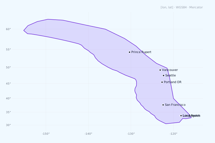
Source: MARPOL Annex VI Reg 13.6.1 + 14.3.3 · MEPC.190(60) · SOx from 01.08.2012 · NOx Tier III for newbuilds from 01.01.2016.
Coverage: Pacific coast of US + Canada, from the Mexican border (San Diego) north through British Columbia to the Gulf of Alaska — Cook Inlet (Anchorage) and Prince William Sound. 200 nm offshore. The offshore boundary is 47 official IMO vertices (MEPC.190(60)); its north-west terminus is Cape Douglas at 58°51′N, 153°15′W.
Excludes: Hawaiian Islands (separate polygon, see below). Mexican Pacific coast. The Aleutian Islands and the Bering Sea — the offshore line ends at Cape Douglas (153°15′W), so Kodiak, Shelikof Strait, Dutch Harbor / Unalaska and Adak are all outside the ECA. There is no partial Aleutian coverage — west of 153°15′W there is no zone.
Major ports inside: Long Beach, Los Angeles, Oakland, San Francisco, Portland OR, Seattle / Tacoma, Vancouver BC, Prince Rupert, Anchorage.
Notes:
- The polygon runs deep north into the Gulf of Alaska to take in Cook Inlet (Anchorage/Homer) and Prince William Sound; south-east Alaska is inside too.
- California has additional local rules (CARB) within 24 nm — 0.10 % sulphur required since 2009, pre-dating the federal ECA. Inside the ECA those rules are now subsumed by the IMO 0.10 % cap.
5. North American ECA — Hawaiian Islands
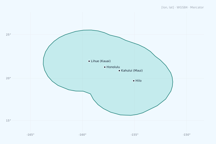
Source: MARPOL Annex VI Reg 13.6.1 + 14.3.3 · MEPC.1/Circ.723 annex 2 §3 · SOx from 01.08.2012.
Coverage: The eight main Hawaiian Islands (Hawai'i, Maui, O'ahu, Moloka'i, Ni'ihau, Kaua'i, Lāna'i, Kaho'olawe) with a 200 nm offshore envelope. 45 IMO-binding points.
Excludes: Northwestern Hawaiian Islands (Papahānaumokuākea — atolls and reefs from Nihoa to Kure). These sit outside the polygon — only the global 0.50 % cap applies there.
Major ports inside: Honolulu, Hilo, Kahului (Maui), Lihue (Kauai).
Notes:
- Frequently overlooked. Hawaiian is officially part of the North American ECA but geographically 2,500 nm from the mainland. Calculators and tables sometimes forget this polygon.
- A clean 45-point geodesic envelope around the entire archipelago.
6. US Caribbean ECA
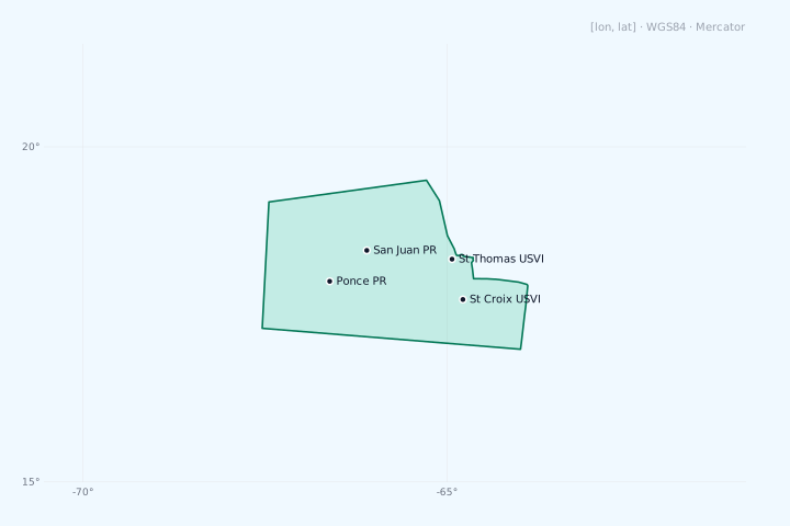
Source: MARPOL Annex VI Reg 13.6.2 + 14.3.4 · MEPC.202(62) · SOx from 01.01.2014 · NOx Tier III for newbuilds from 01.01.2016.
Coverage: Caribbean waters around Puerto Rico + US Virgin Islands (USVI). Extends 200 nm offshore. 55 IMO-binding points.
Excludes: The rest of the Caribbean basin — Cuba, Hispaniola (Dominican Republic + Haiti), Jamaica, the Lesser Antilles, Venezuela, Colombia, Mexican Caribbean. Only the waters around PR + USVI.
Major ports inside: San Juan PR, Ponce PR, St Thomas USVI, St Croix USVI.
Notes:
- Small in area but critical for container voyages to/from Puerto Rico.
- There's a gap between US Caribbean and the North American Atlantic — a ship sailing Miami → San Juan exits NA ECA, runs through open Caribbean (≥ 0.50 % S allowed), enters US Caribbean ECA. Bunker management plans accordingly.
7. Mediterranean SECA
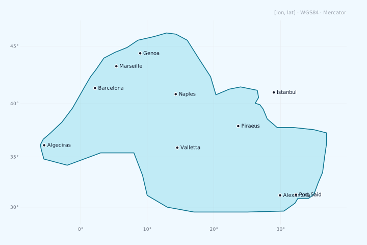
Source: MARPOL Annex VI Reg 14 (new paragraph) · MEPC.361(79) · in force since 01.05.2025.
Coverage: The entire Mediterranean Sea, bounded by:
- West: line from Cape Trafalgar (Spain, 36°11'N 6°02'W) to Cape Spartel (Morocco, 35°48'N 5°55'W) through the Strait of Gibraltar.
- East: Strait of Çanakkale (Dardanelles) — line Mehmetcik Burnu → Kumkale Burnu (40°03'N 26°11'E).
- South-east: Northern entrance to the Suez Canal, excluding a Port Said rectangle (31°29'N — 31°14'N, 32°16'E — 32°32'E).
Excludes: Black Sea (beyond the Bosphorus). Adriatic — yes, included. Aegean — yes, included.
Major ports inside: Algeciras, Barcelona, Marseille, Genoa, La Spezia, Naples, Piraeus, Valletta, Istanbul (on the boundary!), Alexandria, Port Said.
Notes:
- SOx only, no NOx Tier III. Engines in the Mediterranean run any Tier.
- The Bosphorus / Dardanelles and the Sea of Marmara are not formally inside the SECA (eastern boundary sits at the western side of the Dardanelles).
- Port Said exclusion: a small rectangle at the northern end of the Suez Canal is not part of the SECA — done to accommodate transit ships from the Red Sea that can switch fuel after passing Port Said.
8. Canadian Arctic ECA
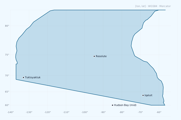
Source: MARPOL Annex VI Reg 13.6.5 + 14.3.6 · MEPC.392(82) (adopted 4 Oct 2024) · NOx newbuilds from 01.03.2026 · SOx from 01.03.2027.
Coverage: Canadian Arctic waters from 137°W (Beaufort Sea, Yukon mainland boundary) east through the Arctic Archipelago, Lancaster Sound, Baffin Bay, to Davis Strait and the northern Labrador coast. 179 IMO points in two segments with Hans Island as the connector.
Includes:
- Beaufort Sea (Canadian sector)
- Northwest Passage (all routes — Parry Channel, Prince of Wales, McClure Strait)
- Arctic Archipelago (Banks, Victoria, Prince of Wales, Bathurst, Devon, Ellesmere Islands)
- Baffin Bay (Canadian side, west of Greenland)
- Davis Strait (Canadian side)
- Hudson Bay + James Bay
- Labrador Sea (Canadian side)
Excludes: Greenland (Danish territory). Alaska (covered by North American Pacific ECA). Russian Arctic.
Major ports / waypoints: Iqaluit (Baffin), Tuktoyaktuk (Beaufort), Resolute (Cornwallis), Churchill (Hudson Bay), Goose Bay (Labrador).
Notes:
- SOx requirements bite only on 1 March 2027. Before that date Canadian Arctic isn't a SOx-ECA — fuel ≤ 0.50 % is fine. NOx Tier III for newbuilds (new engines on contracts placed after 1 March 2026) is the earlier kick-in.
- The largest ECA by area.
- Covers Hudson Bay — critical for routes to Churchill (Manitoba's grain port).
- Hans Island (the disputed Canadian-Danish island in Nares Strait) — the two IMO polygon segments meet there.
9. Norwegian Sea ECA
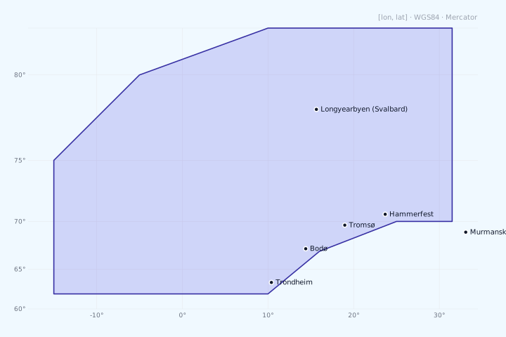
Source: MARPOL Annex VI Reg 13.6.6 + 14.3.7 · MEPC.392(82) (adopted 4 Oct 2024) · NOx newbuilds from 01.03.2026 · SOx from 01.03.2027.
Coverage: Norwegian Exclusive Economic Zone (EEZ) north of 62°N (border with North Sea SECA), to the Russian border (~32°E) in the east, including the waters around Svalbard.
Excludes: Norwegian internal North Sea (south of 62°N — that's North Sea SECA, identical requirements). Russian Barents Sea (east of ~32°E). Greenlandic EEZ.
Major ports / waypoints: Tromsø, Hammerfest, Bodø, Trondheim, Longyearbyen (Svalbard).
Notes:
- SOx requirements bite only on 1 March 2027 (same as Canadian Arctic).
- Boundary defined not by a coordinate list but by reference to MARPOL Annex II Reg 13.9.4 (Norwegian EEZ). We use a 12-vertex EEZ envelope approximation.
- 62°N border with North Sea SECA — that's a handover between two SECAs with identical requirements, effectively seamless.
- Murmansk (Russia, 33.08°E) is outside (east of the boundary).
Regulations that are NOT IMO ECAs but create similar compliance burdens
These are not ECAs under IMO MARPOL Annex VI, but generate ECA-shaped operational obligations for shipowners.
Chinese DECAs (Domestic Emission Control Areas)
China's MSA (Maritime Safety Administration) progressively rolled out its own emission control zones:
- 2016: three regional DECAs designated — Pearl River Delta, Yangtze River Delta, Bohai-rim. Initially 0.50 % sulphur cap inside (no, not 0.10 % — that's the most common confusion).
- 2019: consolidated into a single "China Coastal DECA" covering the entire Chinese coast out to 12 nm from baseline. 0.50 % sulphur cap.
- 2020: Yangtze River + Xijiang River navigable sections — 0.10 % sulphur. This is effectively ECA-style for inland operators.
- 2022: Hainan Island waters — 0.10 % sulphur.
For offshore voyage estimation Chinese DECAs are NOT equivalent to IMO ECAs. The 0.50 % cap matches the global IMO 2020 sulphur cap — so no separate bunker allocation needed for coastal Chinese DECA waters.
The 0.10 % requirements apply only to:
- Inland Yangtze River (Shanghai → Wuhan and beyond)
- Inland Xijiang River (Pearl River basin upstream)
- Hainan Island waters
- At-berth in many Chinese ports (varies by port, governed by local MSA bulletins)
Tool builders: don't add China DECA polygons to your bunker-grade allocation logic for offshore voyages. Do consider them for inland-waterway tonnage or at-berth bunker switch automation.
Hong Kong
Since 1 January 2019 Hong Kong requires ≤ 0.10 % sulphur for all ships in Hong Kong waters (~12 nm). Applies on entry, not just at berth. Practically: vessels switch to LSMGO before crossing into HK waters.
California (CARB)
The California Air Resources Board has required ≤ 0.10 % sulphur within 24 nm of the California coastline since 2009 — predating the federal ECA. Now subsumed by the IMO 0.10 % cap inside the North American Pacific ECA.
At-berth rules
Many ports (Hong Kong, Singapore, EU ports, major Korean ports, German harbours, Turkish ports) require ≤ 0.10 % at berth regardless of whether the area is an ECA. This is a local rule, not IMO.
Australian Great Barrier Reef PSSA
Particularly Sensitive Sea Area, not an ECA — has its own routing measures (compulsory pilotage in inner route, REEFREP reporting) but no sulphur cap. Mention for completeness.
Bunker fuel in practice
What to buy
Universal scheme for a voyage with both ECA and non-ECA segments:
- Inside an ECA-SOx zone: LSMGO (Marine Gas Oil ≤ 0.10 % S) or ULSFO (Ultra-Low Sulphur Fuel Oil ≤ 0.10 % S) or LNG or HSFO + scrubber.
- Outside an ECA: VLSFO (Very Low Sulphur Fuel Oil ≤ 0.50 % S) or ULSFO or HSFO + scrubber.
Most of the world fleet carries VLSFO as the main fuel (post the 2020 IMO sulphur cap), plus LSMGO for ECA segments. The split in the bunker plan depends on the voyage profile.
Prices (indicative, ~2025-2026)
| Fuel | Sulphur | USD/mt (global average) |
|---|---|---|
| HSFO 380 | 3.50 % | $450-500 |
| VLSFO | 0.50 % | $550-620 |
| ULSFO | 0.10 % | $700-780 |
| LSMGO | 0.10 % | $700-800 |
| LNG | 0 % | equivalent $400-500 |
The compliant-ECA premium (LSMGO − VLSFO) is typically $130-200/mt. On an 11,500 nm voyage from Tubarão to Qingdao with 1,500 nm of Med ECA transit, that adds $30-50k to the bunker bill.
Model it for your own voyage: the rynda voyage-economics calculator allocates LSMGO/VLSFO by ECA zone automatically and rolls the premium into TCE — alongside port costs, EU ETS, FuelEU and CII.
Bunker change procedure
Before entering an ECA the ship performs a changeover: switches from tank A (VLSFO) to tank B (LSMGO), flushes the fuel lines. Process takes 30-60 minutes plus a 1-2 hour buffer to be sure only compliant fuel reaches the burner. The bunker logbook documents it.
A port-state-control inspector can sample fuel at any time inside an ECA. Penalties for non-compliance reach $50k+ plus vessel detention.
For developers
Polygons as GeoJSON
polygons.geojson — FeatureCollection of 9 polygons in WGS84. Each Feature's properties contain:
{
  "id": "canadian-arctic",
  "name": "Canadian Arctic ECA",
  "effective": {
    "NOx": "2026-03-01 (newbuilds)",
    "SOx": "2027-03-01"
  },
  "source": "IMO-binding (MEPC.392(82), 179 pts)",
  "point_count": 180
}
Loads into any GIS stack: QGIS, mapbox-gl, leaflet, turf.js, GeoPandas, ArcGIS.
Interactive viewer
viewer.html is a single-file Leaflet viewer that loads polygons.geojson and renders all 9 zones with proper colours, popups (zone name + effective dates), and a base OSM tile layer. Open it directly in a browser — no build step.
HTTP API
/api/ports-map/route returns eca_distance_nm + eca_zones for the whole route and for each leg. Example:
curl -X POST https://rynda.io/api/ports-map/route \
  -H 'Content-Type: application/json' \
  -d '{"ports":["USHOU","NLRTM"]}'
# → { eca_distance_nm: 1481, eca_zones: ["north-american","north-sea"], legs: [...] }
Public, no auth, cached server-side. Suitable for direct embedding in third-party calculators.
FAQ and common confusions
Q: I entered an ECA by accident (storm-driven reroute). What now?
A: Bunker change ASAP. PSC inspectors look at the logbook and bunker delivery notes — if you can show compliant fuel onboard and a switch as soon as you realised, penalties are minimal or none. The key is documentation.
Q: Can I bunker HSFO in Rotterdam if I'm leaving the North Sea SECA within 24 hours?
A: Yes. The sulphur prohibition is on burning fuel inside the ECA, not on bunkering. Vessels routinely bunker HSFO in Rotterdam for downstream non-ECA voyages — Rotterdam is the world's largest HSFO hub.
Q: If my ship has a scrubber, do I need to do anything in an ECA?
A: Switch the scrubber on and make sure outlet emissions meet the 0.10 % equivalent. That's it. Fuel type doesn't matter — burn cheap HSFO.
Q: Mediterranean SECA + Bosphorus — how does it work?
A: Med SECA ends at the western entrance to the Dardanelles (Mehmetcik Burnu). The Sea of Marmara, the Bosphorus, and the Black Sea are not ECA. Transit ship: inside the Med — LSMGO, after Mehmetcik you can switch to VLSFO, in the Black Sea you're on 0.50 %.
Q: When do Norwegian Sea and Canadian Arctic become "real" ECAs for bunker planning?
A: 1 March 2027 for SOx. Until that date, from the voyage-TCE / bunker-allocation perspective those zones are inactive. NOx Tier III for newbuilds (new engines on contracts placed after 1 March 2026) is a capex matter for new ships, not an operational bunker planning issue.
Q: Hawaiian Islands — why a separate polygon if it's part of the North American ECA?
A: Because Hawaii is 2,500 nm from the mainland. Geometrically impossible to describe NA ECA + Hawaii as one polygon (you'd get a trans-oceanic strip cutting across half the Pacific). IMO uses three separate rings under one id 'north-american': Atlantic+Gulf, Pacific, Hawaiian.
Q: Is the Russian Arctic an ECA?
A: No. The Russian sector of the Arctic Ocean (including the Northern Sea Route / NSR) is not an IMO ECA. Russia hasn't joined the Canadian Arctic ECA. NSR voyages have no SOx restrictions under MARPOL Annex VI Reg 14, only the global 0.50 % cap.
Q: Chinese DECA — why isn't it in your polygon set?
A: Because the Chinese coastal DECA caps sulphur at 0.50 % — same as the IMO global cap. There's no extra ECA-style obligation for offshore voyages. Only inland Yangtze / Xijiang / Hainan / at-berth rules require 0.10 %, and those don't change open-water voyage bunker allocation.
Q: How do I check if my ship actually transited an ECA?
A: AIS track + GIS overlay of the polygons. For the ecaNm distance, our ecaDistanceForRoute(coords) function segments the track and computes the share. Inspectors verify via VDR (Voyage Data Recorder), bunker logbook, and fuel sampling if needed.
Q: Is bunker scrubber wash water restricted inside ECAs?
A: IMO Reg 14 doesn't restrict scrubber discharge per se — the requirement is on outlet SOx emissions, not on the wash water. Local rules differ: many EU ports and Singapore restrict open-loop scrubber discharge in port waters, but the open ocean inside an ECA is fine.
References
Official IMO documents
- MARPOL Annex VI Regulation 14 — text covering SOx + PM
- MARPOL Annex VI Regulation 13 — text covering NOx Tier I/II/III
- MEPC.176(58) — Baltic SECA (2008)
- MEPC.190(60) — North Sea + North American (2010)
- MEPC.202(62) — US Caribbean (2011)
- MEPC.1/Circ.723 — North American (incl. Hawaiian) coordinate appendix
- MEPC.1/Circ.755 — US Caribbean coordinate appendix
- MEPC.361(79) — Mediterranean SECA (2022)
- MEPC.392(82) — Canadian Arctic + Norwegian Sea (2024)
Most circulars are on wwwcdn.imo.org/localresources/en/....
IMO landing pages
- Reg 13 NOx ECAs — contains HTML tables with coordinates for all 4 NOx ECAs
- Sulphur 2020 — general sulphur regulation page
Class society / industry sources
- DNV — ECA & SECA Zones overview
- ClassNK — Technical Information T1344e (2024 ECA updates)
- Lloyd's Register — MARPOL compliance bulletins
- LR / Gard / West P&I — practical guidance for shipowners
- Bureau Veritas — Marine & Offshore newsroom (Mediterranean + new ECAs)
Document version
- 2026-05-18 — first public version. Coverage: 9 polygons, 7 ECA zones, full IMO Annex VI as of 2026.
This document is updated when new MEPC resolutions are adopted. The published polygons live in polygons.geojson and power the rynda voyage-economics calculator.